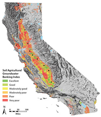
Credit: California Soil Resources Lab, UC Davis
By Diane Nelson, UC Davis
Growers, researchers, policymakers and others can now pinpoint California’s most promising parcels of farmland to help replenish the state’s dwindling groundwater supplies, thanks to a new interactive map developed by the California Soil Resource Lab at the University of California, Davis. The Soil Agricultural Groundwater Banking Index provides site-specific information on millions of acres of California farmland based on previous research led by Toby O’Geen, a UC Cooperative Extension specialist with the UC Davis Department of Land, Air and Water Resources.
Before designing the Web-based map, O’Geen and his team identified about 3.6 million acres of farmland with good potential for groundwater banking, based on how likely the land could accommodate deep percolation with little risk of crop damage or groundwater contamination.
“A lot of growers are interested in learning how they can help improve the groundwater situation in California,” O’Geen said. “The index provides details on the groundwater-recharge potential for any parcel, which you can search for by address or access using your device’s GPS.”
Absorbing El Niño
Water tables have plummeted by more than 100 feet in some areas of California, as growers and others dig more wells and pump deeper into the Earth to replace diminishing surface-water supplies.
If a much-anticipated El Niño arrives this winter, California’s vast acres of farmland may hold the key to groundwater recharge by absorbing rainfall and flood flows.
“During storms and flood-control releases, excess river water could be routed through irrigation canals onto farms, where the surplus would seep underground to replenish groundwater,” said professor Helen Dahlke with the UC Davis Department of Land, Air and Water Resources. “On-farm flooding could also mitigate downstream flood risks.”
Rain check
What can farmers and water managers do in preparation for a potentially wet winter? UC Davis researchers offer these tips:
- Minimize fall applications of fertilizers and pesticides to protect groundwater quality.
- Maximize water infiltration by reducing soil compaction and improving soil structure with cover crops and amendments like mulch, compost, and gypsum.
- Clear and repair irrigation canals this fall, before the storms arrive.
- Clarify water rights as they pertain to capturing and applying large amounts of floodwater to cropland.
This December, Dahlke and a team of scientists will flood almond fields in the Central Valley, building on research that suggests that deliberately flooding farmland in winter can replenish aquifers without harming crops or drinking water.
“Adding an extra few feet of water to even just 10 percent of California’s cropland this winter could add an additional 3 million acre-feet of groundwater,” Dahlke said. “That could go a long way toward replenishing the 6 million acre-feet growers had to pump this year alone to cope with California’s drought.”
One Response to Map IDs farmland with greatest potential for replenishing ground water – from the University of California