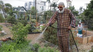
Ibrahim Fardan, one of the directors of Juniper Front Community Garden in San Diego, waters plants in his plot. From the San Diego Union Tribune
By Nan Sterman
If you dream of gardening but live in an apartment or a high rise or simply don’t have the space, don’t give up. Look for a nearby community garden — a piece of land from several acres to less than an acre, divided into garden plots available to local residents. Community gardens are spaces where individuals and families of all ages, races, creeds and levels of experience grow together.
San Diego County is home to more than 80 community gardens from north to south, east to west, and no two gardens are the same. Some are on city property and managed by the local city. Many community gardens are on church property operated independently of the church. School sites are home to community gardens, as are regional parks. UC San Diegohosts nine thriving community gardens and one satellite garden. A community garden in downtown San Diego sits on property belonging to the Port of San Diego.
Community garden plots range from 4 feet by 4 feet up to quarter-acre micro farms. Most gardeners grow for their own use, but larger-scale gardeners sell their produce at area farmers markets. Neighbors learn from neighbors, both formally and informally in community gardens. Some gardens hold member events, including classes on how to grow fruits, vegetables, herbs and flowers.
Typically, community gardens charge a modest fee for each plot to cover the costs of water, shared tools, insurance, classes, etc.
Tijuana River Valley Community Garden
Location: Tijuana River Valley Regional Park
Managed by: Resource Conservation District
Number of plots: 210, from 30-by-30 feet to a quarter acre
Fee: $235/year for a 30-by-30-foot plot
Serves: National City, Chula Vista, Imperial Beach, San Ysidro, San Diego 92154
Information: www.rcdsandiego.org
A very diverse group of gardeners reflects the surrounding community in terms of ethnic diversity and ages, from young families to retired military veterans. This garden’s plots are among the roomiest in the region, so there is plenty of space to grow. It is a peaceful, beautiful garden where each plot reflects the tastes (literally) and style of its owner.
The Resource Conservation District (RCD), which manages this community garden, offers educational workshops to garden members. They’ve planted a hedgerow of native plants along one edge to attract pollinators that do their magic in the vegetable garden plots. Thanks to a recent grant from the California Department of Food and Agriculture, RCD plans to use a section of the garden to test different soil management practices, to determine how each sequesters carbon to reduce greenhouse gases and ease global warming.
Mosaic Community Garden of Chula Vista
Location: 960 Fifth Ave., Chula Vista
Managed by: Self-governing board of directors
Number of plots: 25, ranging from 3 by 7 feet to 5 by 15 feet
Fee: $60/six months, plus deposit
Serves: Nearby residents of Chula Vista
Information: Facebook/Mosaic Community Garden of Chula Vista, @Mosaic.CGCV
Mosaic Community Garden is a privately run garden located on just under an acre of land owned by Shadow Mountain Community Church in Chula Vista. The garden was founded in 2014 with the goal of teaching people to grow food using organic practices. Gardeners of all ages and occupations share this space, including some that come to gardening because they want to improve their diet.
Recently, this garden did a special project with students from High Tech High that focused on healthy eating practices for families. The students were so inspired, they now share a garden plot where they are learning the “Square Foot” gardening method.
This garden also offers workshops to members and to the wider community, some based on gardening, some more art focused, some with an emphasis on science and conservation. Funds from workshop fees go to keep the garden in supplies like water timers, hoses, etc.
Juniper Front Community Garden
Location: 2260 Front St., San Diego, 92101
Managed by: Self-governing board of directors
Number of plots: 52, ranging in size from 50 square feet to 150 square feet
Fee: $90/six months
Serves: Downtown San Diego
Information: Facebook/Juniper Front Community Garden
When you land at San Diego Airport, you pass over the Juniper Front Community Garden, what one member describes as “a little slice of nature in the middle of a dense urban area.” This garden is more than 40 years old, yet its two-year-long waiting list is evidence of its relevance and demand. Long-time members tend to be older, and many are retired; in recent years, the garden has seen an infusion of younger members anxious to grow their own fruits and vegetables.
Most gardeners live in Bankers Hill and other downtown area neighborhoods where properties are smaller and many people live in apartments and other multifamily complexes.
The Juniper Front Community Garden also benefits from outside relationships, including biology students from High Tech High, who have mapped the property and help train members to care for the garden’s shared fruit trees.
GROW at UCSD
Location: Nine gardens on the UC San Diego main campus
Managed by: All on-campus gardens are student run and managed, all under the umbrella of GROW at UCSD
Number of plots: Depends on the garden
Fee: Roger’s Community Garden charges a fee. The others are free.
Serves: Students, staff and faculty, depending on the individual garden
Information: sustainability.ucsd.edu/involve/gardens.html
GROW at UCSD is a coalition of community gardens, organized and operated by undergraduate and graduate students. The students grow food for themselves and their community, including UC San Diego’s on-campus food pantry that serves students facing housing and food insecurity. Roger’s Community Garden is also the site of research projects, including one evaluating a biodigester that produces methane from pre-consumer food scraps generated by Price Center food vendors. Lessons learned from this project could help the university reach its goal of being carbon neutral by 2050.
Getting students outside working in the garden is a balance to their day-to-day classroom time. About a hundred students participate, many of them first-time gardeners who learn informally from the UC San Diego Facilities Management landscape staff and San Diego Master Gardeners. While the number of student gardeners is relatively modest, their reach is much wider, thanks to special events open to the university community. A recent event was a “tea” party, where students picked herbs and brewed tea from their harvest. Another involved making jam from the harvest.
GROW at UCSD is supported by the university’s Sustainability Resource Center Manager and the Vice Chancellor for Resource Management and Planning Sustainability.
Best practices for community gardeners
Grow locally: The best community garden is the one nearest you. The more convenient the garden, the more likely you are to spend time there.
Start small: Many gardens offer different sizes of garden plots. Start small and as you hone your craft, work your way up to larger plots.
Be realistic about time: Vegetable gardens require ongoing monitoring and care. Especially during the growing season, your garden plot needs attention at least twice a week — more in the heat of summer and during harvest. In between, there is weeding, staking, mulching, fertilizing, preparing the soil, and other maintenance to be done. You might even want to pair up with a friend to split duties.
Don’t rush success: Learning to garden is a process, especially if you have no experience. Don’t be shy about asking for help from your more successful neighbors.
Involve kids: Most children and a surprising number of adults have no idea where their food comes from. One of the greatest gifts to give a child is the knowledge and self-sufficiency that comes from knowing how to grow food. And children find great joy from learning the cycles of nature, finding the critters that frequent gardens, and plain ol’ getting dirty and sweaty in the garden.
Think about your neighbors: If you let your plot go to weeds, seeds from those weeds will blow into all the surrounding plots as well. And if you plant a tree in your garden, its branches will soon shade the neighbors’ plots. Stay on their good sides by being considerate.
Ask permission: The next gardener over might have 10 tomato plants covered in ripe tomatoes, and while he or she might be happy to share a tomato or two with you, don’t help yourself without permission.
Participate in the community: While the fruits and vegetables community gardeners grow are priceless, most agree that “community” is their most valuable crop.
Link to article